Key Takeaways
- Bangladesh’s first Ocean Satellite Ground Station at Chittagong University aims to reduce dependency on foreign data for oceanic and weather research.
- Trial operations are set to begin by June 9, 2026, following support from China’s Ministry of Natural Resources.
- The ground station will enhance research capabilities, providing vital data for disaster management and climate change studies.
Bangladesh’s Ocean Satellite Ground Station Overview
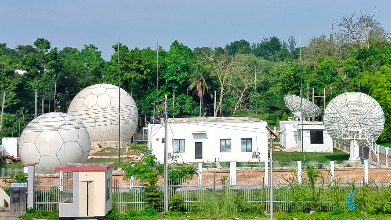
Bangladesh is poised to launch its first Ocean Satellite Ground Station at Chittagong University, marking a significant step in enhancing its scientific research capabilities. Officially commencing operations by June 9, 2026, this initiative aims to decrease the nation’s reliance on foreign agencies for crucial oceanic and meteorological data.
The development of this ground station began on March 26, 2025, with essential technical and instrumental support from China’s Ministry of Natural Resources Second Institute of Oceanography. The inauguration will be attended by Yao Wen, the Chinese ambassador to Bangladesh. Chittagong University has provided land, infrastructure, and operational support, further solidifying its role in this research project.
Once operational, the ground station is expected to dramatically improve Bangladesh’s ability to monitor and respond to climatic events. It will deliver vital oceanographic and meteorological data within 15 to 20 minutes, enabling timely decision-making during natural disasters. The station will support research efforts surrounding climate change, cyclones, river erosion, coastal flooding, and deforestation.
In addition to emergency responses, the facility will analyze crucial factors such as sea surface temperature, salinity, ocean current velocity, and chlorophyll concentration to identify potential fishing zones in the Bay of Bengal. This multifaceted approach will enrich local scientific inquiries and educational programs.
Currently, the ground station is already functioning as a downlink for data from Chinese, Japanese, and NASA satellites that fly over the Bay of Bengal. According to Professor Dr. Mohammad Moslem Uddin from CUs oceanography department, this station serves as a hub for receiving satellite data from multiple sources.
Professor Moslem emphasized that this new infrastructure will significantly help forecast disasters, potentially providing early warnings 48 to 72 hours before an event occurs. Such capabilities are poised to protect lives and property in Bangladesh’s coastal regions, transforming how the nation prepares for and responds to environmental challenges. The establishment of the Ocean Satellite Ground Station illustrates Bangladesh’s commitment to leveraging technology for research and improved public safety.
The content above is a summary. For more details, see the source article.