Key Takeaways
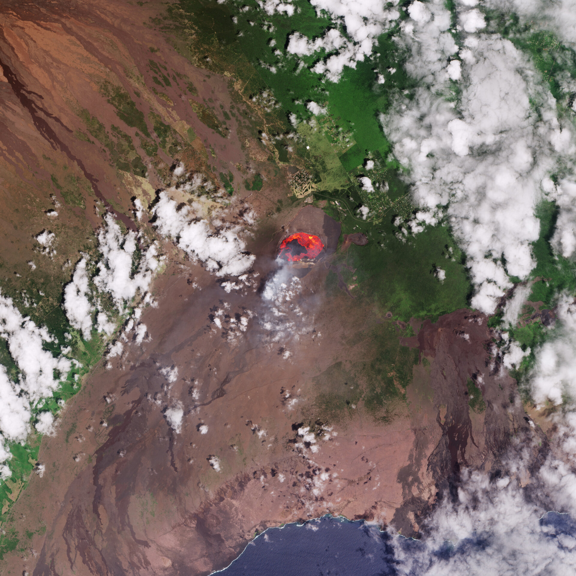
- A recent Copernicus Sentinel-2 image shows an active lava lake at Kilauea volcano on Hawaii’s Big Island, measuring approximately 2.5 km.
- The current eruption phase started on December 23, 2024, following previous eruptive episodes, with lava flows posing minimal threat to local communities.
- Satellite missions like Copernicus Sentinel-2 are vital for monitoring volcanic activity and assessing environmental impacts.
Volcanic Activity in Hawaii
Recent imagery captured by the Copernicus Sentinel-2 satellite highlights the active lava lake within the Kilauea volcano, located on Hawaii’s Big Island. This image, taken on September 3, 2025, reveals a lava lake extending approximately 2.5 kilometers in length inside Kilauea’s main crater. The imagery follows a significant eruptive event on September 2, during which lava fountains soared to about 100 meters, with lava erupting from multiple vents in the crater.
The processed image features natural colors but incorporates shortwave infrared channels to emphasize the intense activity of the lava, depicted in vibrant oranges and reds. Additionally, smoke plumes are visible, billowing from the crater, indicating ongoing volcanic processes. This current eruptive phase began on December 23, 2024, with repeated episodes of lava ejection and flow continuing into 2025.
Older volcanic eruptions have left dark brown remnants on the southern flanks of the crater, showcasing solidified lava flows heading toward the coast. While the recent activity is largely contained within the summit crater and poses minimal risks to nearby residents, it contrasts sharply with the cataclysmic eruption that began in May 2018. That event was one of the most devastating in Kilauea’s history, resulting in the destruction of over 600 homes and the extrusion of lava equivalent to around 320,000 Olympic-sized swimming pools.
The rugged terrain created by volcanic rock is distinct against the backdrop of lush vegetation and agricultural fields surrounding Big Island. Communal areas, roads, and plantations are identifiable in light green and yellow tones to the north of the main crater. The tropical forests of Hawaii, including those on Big Island, thrive due to the combination of fertile volcanic soils and ample rainfall, accentuated by the clouds formed from Pacific trade winds sweeping across the island’s mountainous regions.
Satellites like Copernicus Sentinel-2 play a crucial role in monitoring not only volcanic eruptions, but also related natural phenomena, such as smoke plumes, lava flows, mudslides, and ground fissures. The data obtained from these satellites assists in damage assessment and monitoring the impact of volcanic activities on the environment and local communities.
As Kilauea continues its eruptive behavior, the imagery serves as a reminder of the dynamic and sometimes destructive nature of volcanic activity in this region, while also highlighting the importance of satellite technology in providing real-time data for emergency management and environmental science.
The content above is a summary. For more details, see the source article.