Key Takeaways
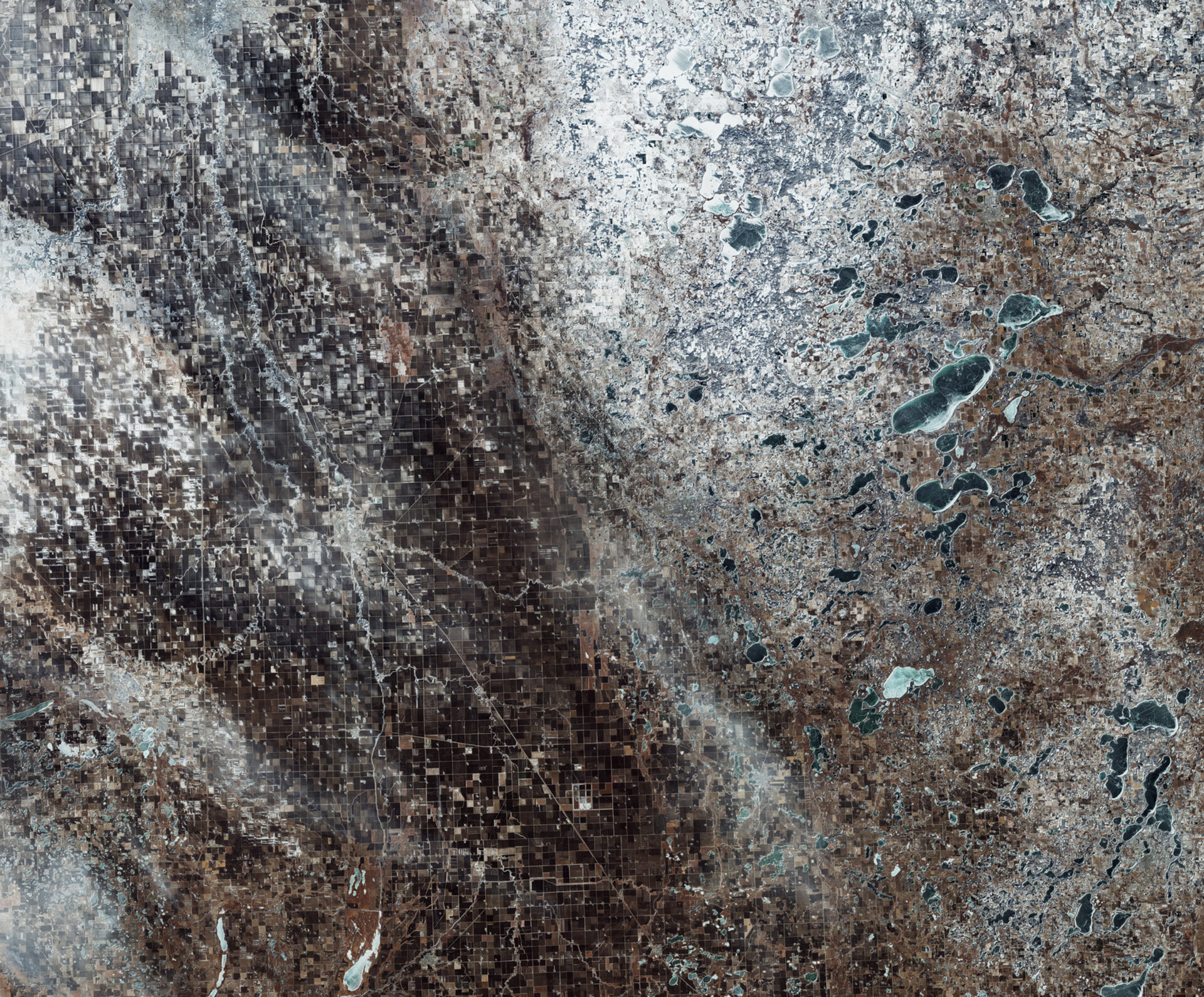
- A Sentinel-2 image showcases the snowy borders of North and South Dakota and Minnesota, highlighting agricultural lands.
- The Red River Valley, known for its fertility, supports crops like soybeans, corn, and wheat.
- The imagery aids the Copernicus programme, facilitating monitoring and management of environmental changes.
Snow-Covered Landscape of the Red River Valley
A recent image captured by the Copernicus Sentinel-2 satellite reveals the snowy terrain along the borders of North Dakota and Minnesota. This striking visual emphasizes the contrast between the agricultural fields predominant on the left side of the image and the snowy landscape on the right. The area is part of the Red River Valley, one of the earth’s most fertile regions.
The image showcases geometric patterns created by the agricultural fields, primarily in shades of brown, though many are currently covered in snow. Agriculture in the region includes a variety of crops such as soybeans, corn, wheat, and sugar beets, all of which significantly contribute to the local economy.
At the center of the image, the Red River of the North is clearly visible, winding its way in white across the landscape. This river, formed by the convergence of the Bois de Sioux River and the Otter Tail River, runs northward for over 700 km, forming the border between North Dakota on the left and Minnesota on the right. The twin cities of Wahpeton, North Dakota, and Breckenridge, Minnesota, are located close to where these rivers meet. Wahpeton is situated just 75 km south of Fargo, a notable location featured in both the film and television series “Fargo.”
On the right side of the image, a mix of agricultural fields, wetlands, and small lakes is visible, many of which are frozen over. Among these bodies of water, Otter Tail Lake stands out, covering an area of approximately 55 square kilometers.
The Sentinel-2 satellite plays an integral role within Europe’s Copernicus programme, delivering critical imagery and data. This information is vital for various applications, including monitoring land use, managing natural resources, and assessing the impact of environmental changes such as floods, forest fires, and landslides. The insights gained from this data support proactive decision-making in agriculture, forestry, and disaster management, highlighting the significance of satellite imagery in understanding and responding to our changing environment.
The content above is a summary. For more details, see the source article.


