Key Takeaways
- Northeast Greenland National Park, the world’s largest national park, covers 972,000 sq km, mostly under the Greenland Ice Sheet.
- Melt ponds on glaciers accelerate ice melting, contributing to rising sea levels and altering global weather patterns.
- Satellite imagery is crucial for tracking changes in the Greenland Ice Sheet and improving climate predictions.
Insight into Greenland’s Ice Landscapes
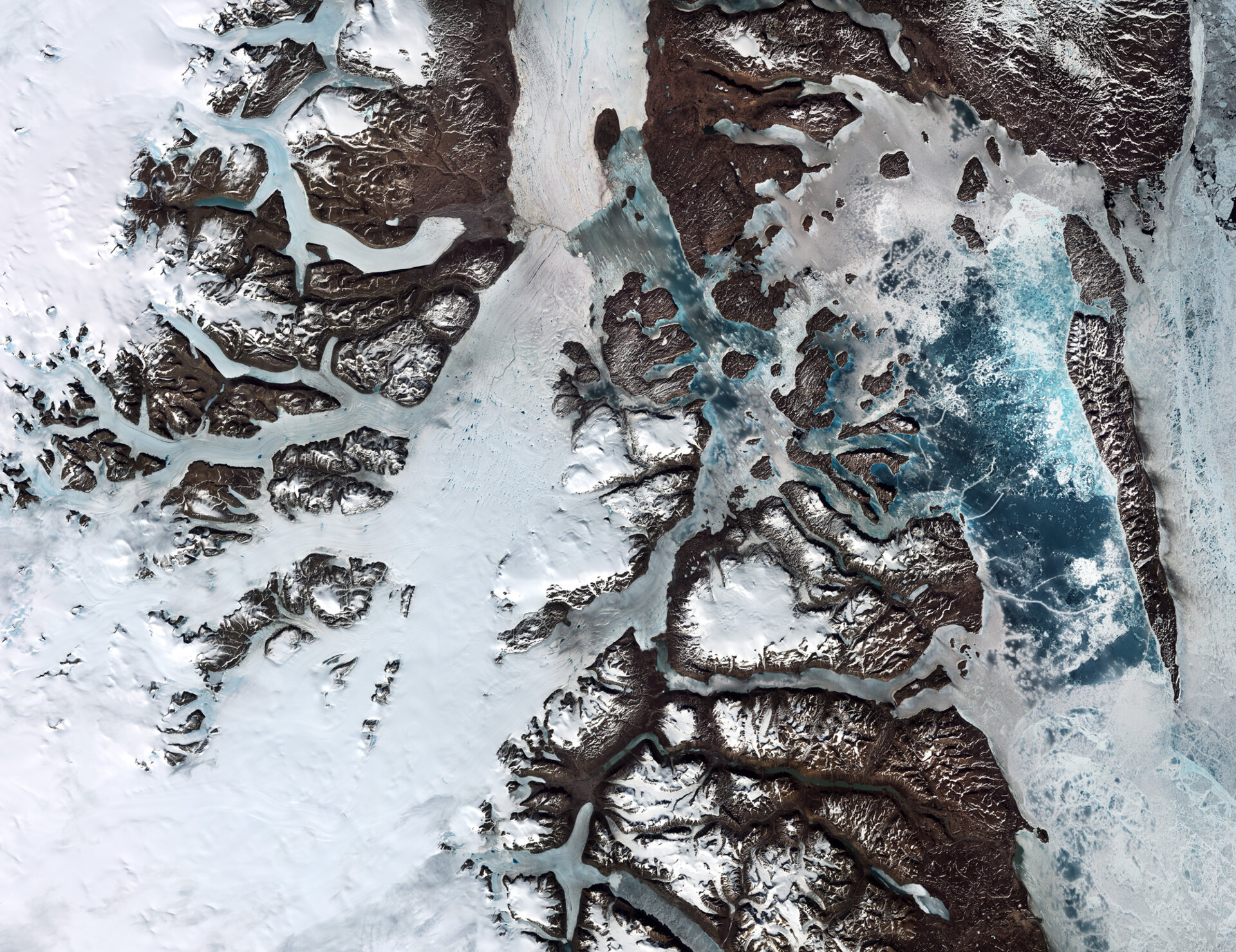
Greenland, the largest island in the world, houses the Northeast Greenland National Park, which spans 972,000 square kilometers—almost equal to the combined areas of Spain and France. This expansive park is predominantly covered by the Greenland Ice Sheet, the second-largest ice sheet globally after Antarctica.
Recent imagery from the Copernicus Sentinel-2 mission captures the vibrant landscapes of the park, where soil colors range from light to dark brown, snow and ice glow white, and a spectrum of blue indicates varying water bodies. Dove Bay, located on the right of the image, shows signs of seasonal breakup, revealing sections of open water.
At the southern shore of the Germania Land Peninsula is the Danmarkshavn weather station, one of the world’s most isolated inhabited locations. This station, manned by a six-person team, plays a critical role in international weather forecasting by collecting vital meteorological data.
Melt ponds are a notable feature depicted in the imagery and occur as the air warms in spring and summer. These ponds form on both sea ice and the ice sheet, accumulating from melting surface ice and snow. Their presence is crucial, as they decrease the reflecting capability of ice, allowing for greater heat absorption and subsequently increasing the rate of ice melt. Although the melting sea ice does not directly impact global sea levels, the accelerated melting of land-based ice significantly contributes to rising sea levels.
Rising sea levels pose risks of flooding in coastal regions worldwide, disrupt Arctic marine ecosystems, and modify oceanic and atmospheric circulation. Such changes inevitably affect global weather patterns.
The significance of satellite imagery in this context cannot be overstated. It serves as an essential tool in mapping the rapidly transforming Greenland Ice Sheet. By providing detailed observations from space, these images help validate climate models and enhance predictions regarding the potential influence of Greenland’s ice on future global sea levels.
In summary, the interplay between melt ponds and the accelerating changes of the Greenland Ice Sheet underscores the urgent need for continued monitoring and analysis. Through satellite technology, scientists can better anticipate the implications of these changes, aiding efforts to address global climate challenges.
The content above is a summary. For more details, see the source article.