


Key Takeaways
- Google’s Ask Google Earth now allows users to find infrastructure types within specific areas, enhancing urban planning efficiency.
- The feature integrates infrastructure data into BigQuery, enabling the tracking of key assets like street signs and utility poles.
- Despite improving infrastructure grades, mayors have deprioritized infrastructure funding due to financial constraints.
New Features for Urban Planning
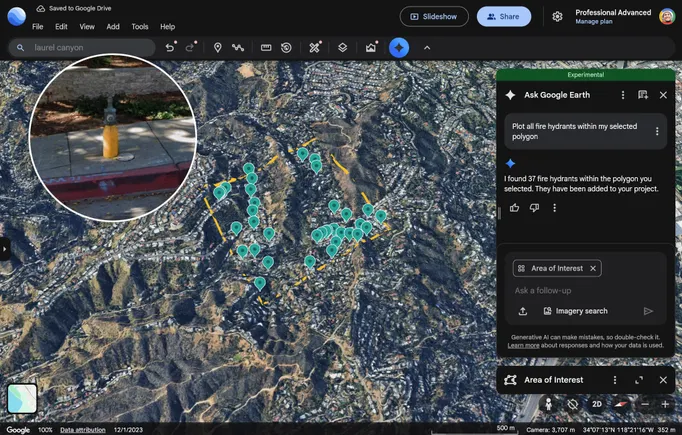
Google has enhanced its Ask Google Earth platform, enabling users to locate specific infrastructure types within defined regions. This new feature aims to streamline urban planning and analysis by allowing access to detailed infrastructure data. Users can now track important elements, including fire hydrants, speed limit signs, stop signs, street lights, traffic lights, utility poles, storm drains, and manhole covers.
This update integrates infrastructure data into BigQuery, Google’s AI data analytics platform, offering users advanced capabilities. Furthermore, the platform features Street View imagery, which allows users to assess the condition of critical infrastructure elements, such as utility poles and road signs.
Infrastructure Gains and Priorities
A recent report from the American Society of Civil Engineers gave U.S. infrastructure its highest grade to date, a C, improved from a C- in 2021. While this is an encouraging sign, a 2025 National League of Cities survey revealed that infrastructure has dropped in priority among mayors. It now ranks fourth, whereas it typically held a top position in previous years.
This shift is largely attributed to financial strains arising from tariffs and bond issues affecting cities. According to Farhad Omeyr, director of research and data for the National League of Cities, dwindling funds from the 2021 Infrastructure Investment and Jobs Act may also contribute to this decline in priority. Omeyr emphasized that a lack of funds does not equate to resolved infrastructure issues, suggesting that the need for strategic planning remains.
A separate survey indicated that cities are tightening their budgets, reflecting these fiscal challenges. In light of this, Google is promoting its Ask Google Earth feature as a tool to optimize infrastructure spending. By offering services such as Imagery Insights, city planners can pinpoint the number and locations of signs needing repairs, thereby making informed decisions about resource allocation.
Google’s integration of Street View imagery with infrastructure data is presented as a means to facilitate smarter, data-driven choices for improved planning and efficiency. This innovation serves as a potential solution for cities grappling with budget constraints while seeking to maintain and improve vital infrastructure services.
The content above is a summary. For more details, see the source article.


