


Key Takeaways
- A severe thunderstorm outbreak is affecting nine states, with a *Moderate Risk* identified for strong tornadoes, hail, and damaging winds.
- Peak threats are expected from Friday afternoon through night, particularly along I-35, I-29, and I-94 corridors.
- Drivers are advised to seek shelter and avoid travel in the threat zone, especially during supercells and squall lines.
Severe Thunderstorm Outbreak Across Nine States
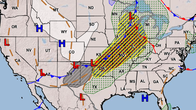
A significant severe thunderstorm event is taking place across nine states from the southern Plains to the Upper Mississippi Valley today, April 17, 2026. The Storm Prediction Center (SPC) has marked a *Moderate Risk* in the southern and central Plains, indicating a heightened threat for strong tornadoes, large hail, and damaging winds extending into tonight.
Currently, a Tornado Watch is in effect for much of eastern Iowa, accompanied by a Severe Thunderstorm Watch for eastern Minnesota and central-to-northern Wisconsin. Areas such as Rochester, Eau Claire, and La Crosse are particularly at risk, with hail sizes potentially reaching 2 inches in diameter and wind gusts hitting isolated peaks of 70 MPH.
Meteorologists anticipate the peak danger for severe weather to occur from Friday afternoon through the evening. Regions including I-35 from central Texas to Kansas, I-29 through Iowa, and I-94 across Minnesota and Wisconsin are highlighted as the most critical areas where initial supercells could spawn strong tornadoes before transitioning to a damaging wind squall line after dark.
What to Expect
- Tornadoes: A 10% probability is forecast across the moderate risk zone, with the potential for strong (EF2+) tornadoes arising from supercells in Wisconsin and Iowa.
- Hail: There is a 30% probability for severe hail, with reports of hailstones likened to hen eggs.
- Damaging Winds: A 45% probability for damaging winds suggests gusts could reach up to 70 MPH as storms coalesce into a squall line.
The synoptic conditions are ripe for this severe weather outbreak. A robust upper trough from Montana to the Southwest is anticipated to move eastward into the Plains. An accompanying dryline and cold front will establish a warm and unstable atmosphere, marked by mid-to-upper 60s dew points and temperatures climbing into the 80s.
Road Safety Concerns
Road conditions are projected to worsen in two phases. Initial supercells could produce hail ranging from golf-ball to hen-egg size, making driving dangerous due to sudden visibility impairment and potential damage to vehicles. As the cold front sweeps in, attention will shift to a fast-moving squall line with high winds that could endanger drivers, especially those in high-profile vehicles. Flash flooding is another concern, with rainfall rates predicted to reach 1-2 inches per hour.
Hail Damage
Hail damage poses significant financial risks to vehicle owners, historically costing over $1.2 billion in claims. Comprehensive auto insurance is essential for coverage against hail damage, with claims exceeding the vehicle’s actual cash value often leading to total losses.
Driving Recommendations
For those in affected areas, it is crucial to stay off the roads when severe storms are expected. Drivers should seek shelter immediately when storms approach and avoid taking cover under overpasses during tornado warnings, as these areas increase wind speeds rather than offer protection. Familiarizing oneself with local alert systems and having a clear emergency plan is advisable.
Initial severe weather activity is already occurring in eastern Iowa and the upper Mississippi Valley this afternoon, with the situation expected to escalate into the evening. The transition to a destructive wind squall line is likely as storms evolve, indicating that conditions will improve behind the front by Saturday, though further severe weather could arise on Sunday in the Mid-South. Updates will be provided as the situation develops.
The content above is a summary. For more details, see the source article.


