Key Takeaways
- The Gibson Desert in Western Australia spans over 150,000 sq km, featuring red sandy plains and unique soil colors due to iron-rich sediment.
- The landscape is characterized by parallel sand dune ridges and ephemeral rivers, with the Fortescue River prominently depicted in a dry state.
- Φsat-2, a miniature satellite launched in August 2024, aims to enhance Earth observation using advanced Artificial Intelligence technologies.
Exploring the Gibson Desert from Space
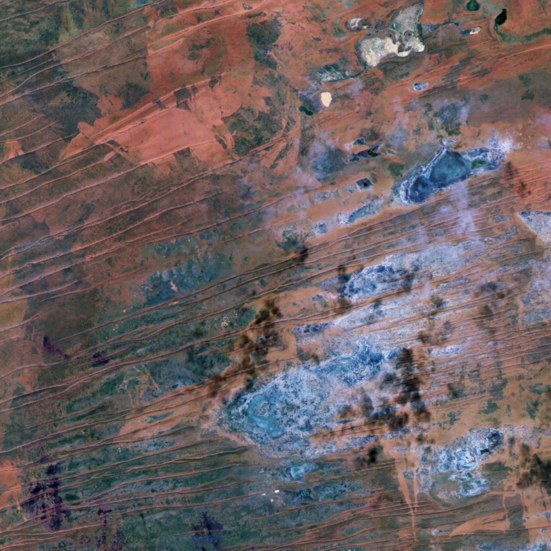
The Gibson Desert, located in Western Australia, is a vast region encompassing over 150,000 square kilometers. This arid landscape features a diversity of terrains, including gravel plains adorned with desert grasses, red sandy expanses, and dune fields. An image captured by the Φsat-2 mission in June 2025 highlights these characteristics, showcasing the desert’s typical reddish-brown soil surface, which is attributed to iron-rich sediments. The region’s dry climate promotes soil oxidation, contributing to the striking warm hues of the terrain.
A notable aspect of the Gibson Desert is the presence of parallel sand dune ridges, shaped by wind action and extending for kilometers across the landscape. In the lower section of the captured image, the largest blue feature is a dry lakebed where the Fortescue River once flowed. The river’s current dry state indicates the ephemeral nature of most rivers in this region, which flow only temporarily in response to rainfall. The absence of significant precipitation prior to the image acquisition explains the Fortescue River’s lack of water.
Inland drainage patterns are customary throughout much of Western Australia, where most lakes consist of saline dry lakebeds rather than freshwater sources. The image also reveals a partially white body of water at the top, indicative of the Fortescue Marsh wetlands. This area, different from traditional permanent lakes, is a seasonal floodplain that retains water during and after rainfall events, making it crucial for local flora and fauna adapted to the region’s harsh conditions.
The Fortescue Marsh is recognized nationally as an important wetland, hosting a variety of species that thrive in its unique environment. The region’s ecological significance underscores the importance of understanding and monitoring such landscapes.
Enhancing our knowledge of these environments is the Φsat-2 satellite, which was launched in August 2024. This miniature cubsat is tasked with showcasing the advancements of various Artificial Intelligence technologies in the realm of Earth observation. By leveraging sophisticated AI tools, Φsat-2 aims to improve our ability to monitor and analyze different natural situations from space, particularly the dynamic ecological systems like those found in the Gibson Desert and Fortescue Marsh.
Through missions like Φsat-2, the exploration and understanding of remote and often overlooked environments can be significantly improved, shedding light on their ecological importance and the need for conservation efforts in changing climatic conditions.
The content above is a summary. For more details, see the source article.