
Key Takeaways
- Recent earthquakes in Egypt and Colombia highlight the necessity for advanced technologies in disaster response.
- The UAE is leading international efforts to utilize space science for enhanced disaster management through the International Charter: Space and Major Disasters.
- Multiple activations of the Charter have supported countries in managing emergencies like floods and earthquakes by providing real-time satellite data.
Advanced Technology in Disaster Relief
Recent earthquakes in Egypt and Colombia have emphasized the critical need for rapid and accurate information during natural disasters. The 5.6-magnitude tremor in Egypt and the 7.4-magnitude quake in Colombia on August 10, 2026, illustrate the importance of technologies that aid emergency authorities in assessing damage, identifying affected areas, and coordinating relief efforts.
Space science and technology are pivotal in addressing these needs. Tools such as satellite imagery, geospatial data, data analytics, and artificial intelligence are enabling governments and humanitarian agencies to gather timely intelligence and make more informed decisions during crises.
The International Charter: Space and Major Disasters plays a vital role in utilizing space-based resources for disaster management. The UAE has been actively contributing to this global mechanism, particularly during its presidency from April to October 2026, under the UAE Space Agency. This leadership involved deploying satellite imagery and geospatial data to assist affected countries across various natural disasters, enhancing the speed and accuracy of emergency assessments to protect lives and infrastructure.
Collaboration is key in this effort. The UAE Space Agency partnered with the National Emergency Crisis and Disaster Management Authority, the Mohammed Bin Rashid Space Centre, and Space42 to integrate satellite technology with emergency management expertise. The Charter has facilitated responses to numerous emergencies, including floods, earthquakes, and volcanic eruptions.
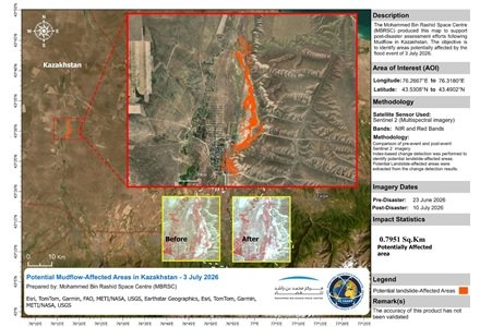
For example, in Kazakhstan, a Charter activation in July 2026 helped monitor severe flooding by providing real-time satellite imagery, supporting government decisions during the crisis. Similarly, Charter responses benefited areas affected by wildfires, earthquakes in Venezuela, and floods in Kyrgyzstan, showcasing the effectiveness of space technology in crisis management.
The Charter’s initiatives have also reached the Philippines and New Zealand, where satellite data facilitated monitoring of volcanic activity and flooding respectively. In Papua New Guinea, satellite imagery was instrumental in responding to Cyclone Mayla, allowing for effective emergency operations and community assistance.
The UAE’s leadership in the Charter not only reflects its growing role in the global space sector but also demonstrates the power of international collaboration in leveraging space capabilities for humanitarian purposes. Since its inception, the Charter has conducted over 1,168 activations, supporting 146 countries using a vast network of satellites. This global initiative continues to exemplify how cooperation in space technology can enhance disaster response and preparedness worldwide.
The content above is a summary. For more details, see the source article.