

Key Takeaways
- The Boston kerb network map project aims for completion by May 2026.
- Combining AI and real-time information will enhance kerb management and parking solutions.
- The initiative focuses on improving urban infrastructure through advanced planning techniques.
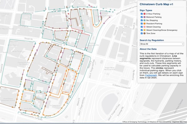
The Boston kerb network map project is set to transform urban parking and kerb management through the integration of artificial intelligence and real-time data sharing. Scheduled for completion in May 2026, this initiative aims to create a comprehensive digital map that will facilitate better planning and management of city kerbs.
The project addresses existing challenges in urban infrastructure, particularly in parking systems that often lead to congestion and inefficient space utilization. By leveraging AI technology, the project will provide a dynamic mapping solution that can adapt to changing conditions in real time, allowing city planners and drivers to access updated information.
One of the key benefits of this digital map is the potential for improved parking solutions. The project will enable better allocation of parking spaces, streamlining traffic flow and reducing the time spent searching for parking. This can significantly enhance the overall driving experience in urban areas by minimizing delays and frustrations commonly associated with parking.
In addition to parking, the kerb management aspect of the project will focus on optimizing the use of street space for various purposes, including deliveries, ride-sharing, and public transport. The goal is to create a more organized and functional urban environment, ensuring that kerbs are utilized efficiently and effectively.
Boston’s initiative represents a forward-thinking approach to urban planning, incorporating modern technology to tackle age-old issues. The collaborative effort is expected to yield substantial benefits not only for city planners but also for residents and visitors alike, contributing to a more integrated and accessible urban landscape.
As the project progresses toward its 2026 deadline, stakeholders will continue to gather input from the community to refine and enhance the digital map’s features. This engagement is crucial to ensure that the final product meets the needs of all users, from city officials to everyday drivers.
Overall, the Boston kerb network map project signals a significant step forward in urban management, heralding a new era of smart city solutions that prioritize efficiency and usability. The effective implementation of this initiative could serve as a model for other cities facing similar challenges in parking and kerb utilization.
The content above is a summary. For more details, see the source article.