Key Takeaways
- Copernicus Sentinel-1C satellite is already demonstrating its radar capabilities for precise Earth surface mapping.
- The satellite is instrumental for applications including disaster monitoring, subsidence analysis, and marine surveillance.
- Preliminary datasets from Sentinel-1C are now available, enhancing the mission’s effectiveness for surface deformation monitoring.
Launched just two months ago, the Copernicus Sentinel-1C satellite is quickly showcasing the potential of its radar data for mapping the Earth’s land surface with remarkable accuracy. Currently in the commissioning process, Sentinel-1C already demonstrates its capabilities in monitoring subsidence, uplift, glacier flow, and natural disasters like landslides and earthquakes through advanced “interferometry” techniques.
Equipped with C-band Synthetic Aperture Radar (SAR), Sentinel-1C follows in the footsteps of its predecessor, Sentinel-1A, launched in 2014. This technology has continually set new benchmarks in spaceborne radar for Earth observation, offering high-resolution imagery regardless of weather conditions or time of day. Its applications extend across various Copernicus services, including monitoring Arctic sea ice, tracking icebergs, and maintaining routine glacial measurements. Additionally, Sentinel-1C plays a critical role in marine surveillance activities, such as detecting oil spills, ship tracking for enhanced maritime security, and monitoring illegal fishing activities.
The mission has proven crucial for observing ground deformation resulting from subsidence, uplift, earthquakes, landslides, and volcanic activity, thereby significantly supporting humanitarian efforts and disaster response globally. Utilizing a complex data processing method known as Synthetic Aperture Radar interferometry (InSAR), the mission combines multiple radar images captured at different times to create an interferogram revealing surface displacement. This technology is especially valuable when analyzing land shifts post-earthquake.
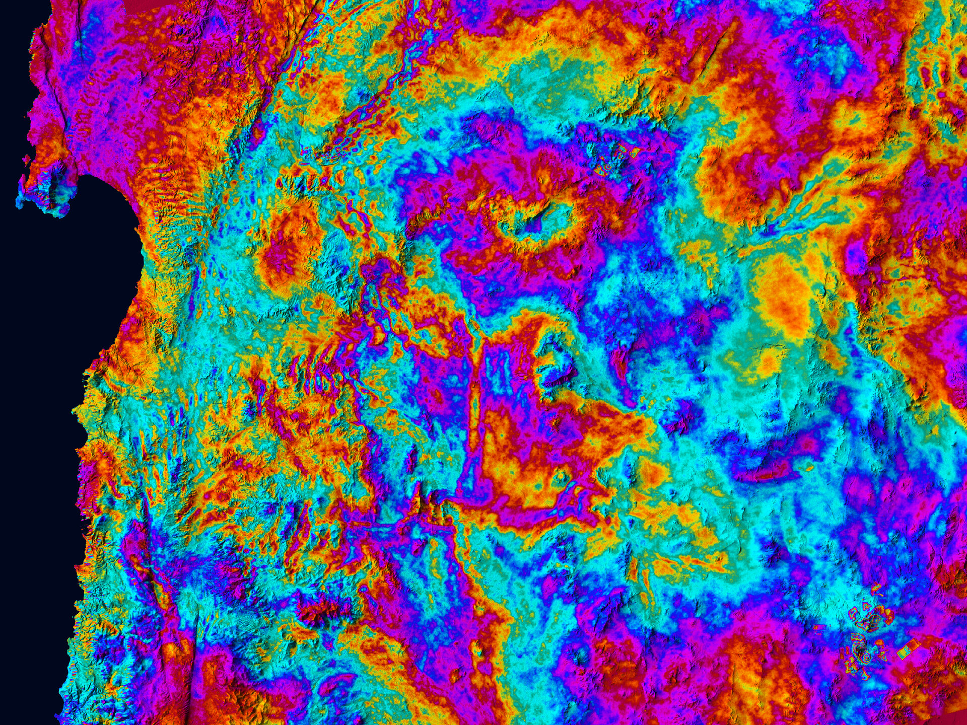
The preliminary results include cross-satellite interferograms, notably one from the Atacama Desert in northern Chile, generated from images acquired just a day apart by Sentinel-1A and Sentinel-1C. The interferogram for the Antofagasta area, which relies solely on Sentinel-1C data, highlights the satellite’s 12-day orbital repeat interval. Despite the vibrant colors in the radar images reflecting the topography, they do not indicate surface deformation but rather serve to calibrate the satellite’s radar capabilities.
Dirk Geudtner, ESA’s Sentinel-1 System Manager, expressed satisfaction with the initial results and praised the calibration team for their efforts. He highlighted the importance of proper synchronization between the satellites for achieving accurate data. He further noted that these initial outcomes confirm Sentinel-1C’s ability to carry on its vital mission of monitoring ground deformation, an essential aspect for effective disaster response.
ESA’s Sentinel-1 Project Manager, Ramón Torres, also shared enthusiasm for the promising results from Sentinel-1C, emphasizing that quality in space missions requires dedicated intention and expertise. Nuno Miranda, responsible for operational management of the Sentinel-1 satellites, underscored that the cross-satellite interferogram marks a significant advancement in restoring the full operational capacity of the satellite constellation, particularly for surface deformation monitoring.
A preliminary dataset from Sentinel-1C is now available for users, who can start preparing their applications. This dataset will soon be enriched with additional data from the new satellite, further enhancing its utility for various critical monitoring services.
The content above is a summary. For more details, see the source article.